Pueblo de San Jose, 1781 (1979-861-1)
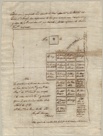
This 1 June 1781 map of Pueblo de San Jose de Guadalupe is the first known map of what is today San Jose, California. This map represents the original site of the pueblo from November 1777 to approximately 1791, located approximately between Guadalupe Freeway, Hedding Street, North First Street and Hobson Street.
This map represents the suertes (farm lots) that were outside the pueblo proper. The pueblo proper is seen as a square at the top of the map, marked with a cross. Within that square would have been the solares (town lots). The outlying suertes are seen as the 21 squares with names in them. These lots were irrigated by the Guadalupe River, which fed into the farm lots via the main water ditch, seen at the upper right side.